|
|
စုဖွဲ့ဖော်ပြခြင်း (Relations)
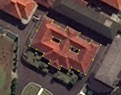
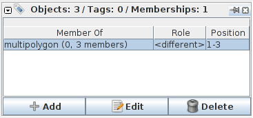
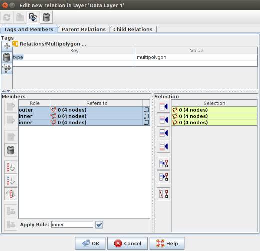
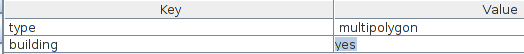
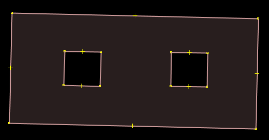
In the Beginner’s Guide we explained that there are three types of objects that can be drawn in OpenStreetMap - points (nodes), lines (ways), and polygons (closed ways). Lines contain numerous points, and the line itself carries the attributes that define what it represents. Polygons are the same as lines, except that the the line must finish where it begins in order to form a shape. ထို့အပြင် Relations ဟုခေါ်သော အမျိုးအစားတစ်ခုကိုလည်း OpenStreetMap မြေပုံများတွင် တွေ့မြင်နိုင်သည်။ မျဉ်းကြောင်းများအပေါ်တွင် အမှတ်များပါလေ့ရှိသကဲ့သို့ Relation တစ်ခုတွင်လည်း အမှတ်၊မျဉ်းကြောင်းနှင့် ဗဟုဂံပုံစသည့် အစုအဝေးများပါဝင်နိုင်ပါသည်။ မြေပုံရေးဆွဲမှုစွမ်းရည် တိုးတက်လိုပါက relations များကို ပြုပြင်တည်းဖြတ်ခြင်းကိုလည်း နားလည်သိရှိရန်လိုအပ်သည်။ ဥပမာ။ အလယ်တွင် ကွက်လပ်ချန်လျက် လေးဘက်လေးတန် ကာရံဆောက်လုပ်ထားသော အဆောက်အဦကို မြေပုံထုတ်သည်ဆိုပါစို့။ အဆောက်အဦ၏အပြင်ဘက်အနားကို ခြုံငုံမိသောဗဟုဂံပုံတစ်ခုနှင့် အလယ်ကွက်လပ်ကိုကန့်သတ်ပြထားသောဗဟုဂံပုံများလိုအပ်မည်။ သို့မှသာယင်းကွက်လပ်ကို အဆောက်အဦ၏အစိတ်အပိုင်းတွင်မပါဝင်ကြောင်း ညွန်ပြနိုင်မည်ဖြစ်၏။ ထိုသို့ရေးဆွဲထားခြင်းကို relation ဟုသတ်မှတ်သည်။ Relation တွင် ဗဟုဂံပုံများစွာပါဝင်နိုင်ပြီး အဆောက်အဦ၏သတ်မှတ်ဖော်ပြချက်များကို ဗဟုဂံပုံများတွင်မဟုတ်ဘဲ relation တခုလုံးနှင့်တွဲစပ်ပေးရမည်။
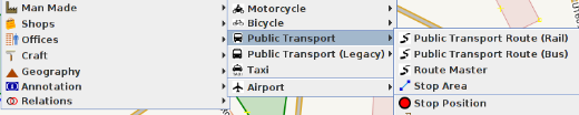
မြေပုံပေါ်ရှိ အရာဝတ္ထုများကိုစုဖွဲ့ပြလိုလျှင် Relations ကိုအသုံးပြုသည်။ အခြားဥပမာများမှာ … ဘတ်စ်ကားလမ်းကြောင်းများ၊ မြစ်နှင့် လမ်းမများကဲ့သို့ ရှည်လျားရှုပ်ထွေးသောအရာများ၊ တက္ကသိုလ်အဆောက်အဦများကဲ့သို့ တနေရာတည်းတွင်စုဝေးတည်ရှိသော ဗဟုဂံပုံအမျိုးမျိုးတို့ကိုစုဖွဲ့ပြလိုလျှင်အသုံးပြုသည်။ OpenStreetMap တွင်တွေ့ရှိနိုင်သော Relations အမျိုးအစား ၄ မျိုးရှိသည်။ ယင်းတို့မှာ ဗဟုဂံပုံအမျိုးမျိုး၊ လမ်းကြောင်းများ၊ နယ်မြေသတ်မျဉ်းများနှင့် တားမြစ်ကန့်သတ်ချက်များ ( ဥပမာ.“ဘယ်”မကွေ့ရ) တို့ဖြစ်သည်။ ယခုသင်ခန်းစာတွင် ဗဟုဂံပုံအမျိုးမျိုးနှင့် လမ်းကြောင်းဖော်ပြချက်များကိုရှင်းလင်းပြသမည်ဖြစ်သည်။ ဗဟုဂံပုံအမျိုးမျိုးပါဝင်သော Relations များဖန်တီးခြင်းရှေ့ပိုင်းတွင်ဖော်ပြခဲ့သော ဗဟုဂံပုံ relation ကဲ့သို့အရာကို ရေးဆွဲရန်လေ့လာကြပါစို့။
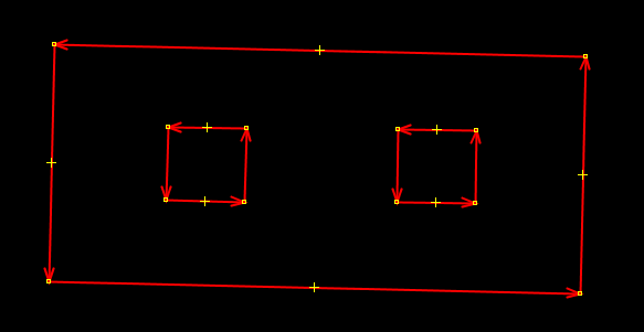
ထိုသို့သော ဗဟုဂံပုံအမျိုးမျိုးကိုဖန်တီးပြီးပါ ကမြေပုံပေါ်တွင် အောက်ဖော်ပြပုံအတိုင်း တွေ့မြင်ရမည်ဖြစ်သည်။
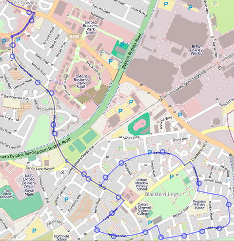
အတွင်းအပြင်ခွဲခြားဖော်ပြရန်လိုအပ်သော ရှုပ်ထွေးသည့်အဆောက်အဦများ၊ ကျွန်းပေါ်ထွန်းသည့်မြစ် များကိုရေးဆွဲရာတွင် ဗဟုဂံပုံအမျိုးမျိုးပါဝင်သော အစုအဖွဲ့ကိုအသုံးပြုသည်။ အသေးစိတ်လေ့လာလိုပါက OSM Wiki တွင်ဝင်ရောက်ကြည့်ရှုနိုင်ပါသည်။ လမ်းကြောင်းအစုအဖွဲ့ဖော်ပြသည့် Relationsလမ်းကြောင်းရှည်များကို ဖော်ပြရာတွင် relations ဖြင့်ပြသခြင်းကအသုံးဝင်သည်။ ဥပမာ။ ဘတ်စ်ကားလမ်းကြောင်း၊ စက်ဘီးလမ်းကြောင်းများတွင် လမ်းပိုင်းများစွာပါဝင်လေ့ရှိသည်။ ထိုသို့သော လမ်းကြောင်းများကို ဖော်ပြရာတွင် မည်သည့်လမ်းပိုင်းများပါဝင်သည်ကို relation ချိတ်ဆက်ဖော်ပြနိုင်သည်။ ကားမှတ်တိုင်ကဲ့သို့ ထပ်ဆောင်းဖြည့်စွက်မှုများလည်း relation တွင်ထည့်သွင်းနိုင်သည်။ (အောက်ပုံတွင်ရှု)
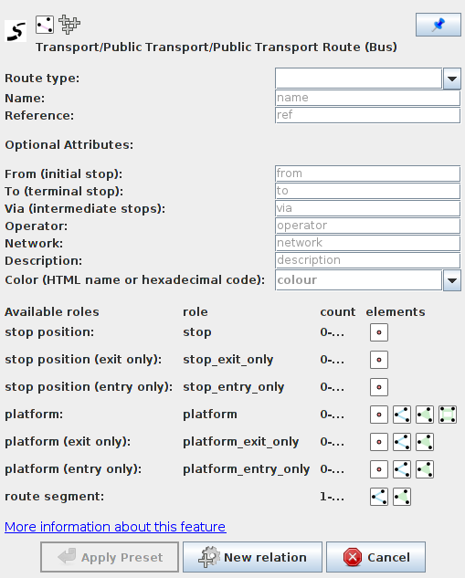
JOSM ဆော့ဖ်ဝဲလ်တွင် ဘတ်စ်ကားလမ်းကြောင်းပြ မြေပုံတစ်ခုရေးဆွဲခြင်းကိုလေ့လာကြည့်ပါမည်။
It is important to select the specific route type from the dropdown menu at the top. For bus routes two options are available, bus and trolleybus. Typically you would also enter name, reference number, from and to.
အကျဉ်းချုပ်ဖော်ပြချက်Relations များသည် နားလည်ရခက်ပြီး မကြာခဏအသုံးပြုရခြင်းမျိုးလည်းမရှိချေ။ သို့သော်နားလည်ထားရန်လိုအပ်ပေသည်။ မြေပုံရေးဆွဲရာတွင် relations အသုံးပြုရန်လိုအပ်လာပါက ယခုလေ့လာထားသည်များကို ပြန်လည်အသုံးချနိုင်ရန်အတွက်ရည်ရွယ်ပါသည်။ OSM Wiki တွင်ဖော်ပြထားသော အချက်အလက်များကလည်း သင့်ကို ကူညီထောက်ပံ့ပေးပါလိမ့်မည်။
ဤအခန်းသည် သင့်အတွက်အထောက်အကူပြုပါသလား။
ကျွန်ုပ်တို့၏လမ်းညွှန်မှုများကိုတိုးတက်ကောင်းမွန်စေရန် ကျွန်ုပ်တို့အားအသိပေးခြင်းဖြင့်ကူညီပါ။
|
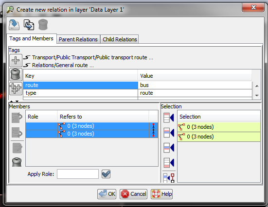
 ထိုအကွက်တွင်ပြုလုပ်ပြီးခဲ့သော relations များကို ပြုပြင်တည်းဖြတ်ခြင်း၊ အသစ်ရေးဆွဲခြင်းများပြုလုပ်နိုင်သည်။