|
|
Tasking Manager Administrator GuideIf the user interface of the version you use looks different from the one described here then you should consult our version overview Section Index
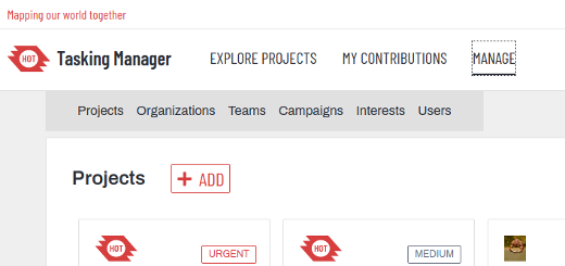
The Tasking Manager is the essential tool to coordinate mapping on OpenStreetMap. It supports humanitarian mapping initiatives, conducting mapathons or creating mapping tasks for students. The application divides an area of interest into manageable geographic chunks that can be completed rapidly and collaboratively. This approach allows the distribution of tasks to many individual mappers, while reducing possible editing conflicts. The Software encourages accurate and quality mapping data by providing a consistent set of instructions for your mappers (e.g. ‘map all roads and buildings’). In short, the Tasking Manager is how you set up and direct the workflow for open mapping activities. This guide describes the basic administration of the Tasking Manager. It covers instructions to create and modify mapping projects and handling permissions for mapping and review of crowd-sourced data. Login and accessIn order to login to the Tasking Manager an OpenStreetMap (OSM) account is needed. You can visit the HOT Tasking Manager, or any other community instance of your preference. There click PermissionsThe most basic user level is mapper. Mappers are able to login to the Tasking Manager to find and select a mapping project to work on. All mapper functionality is described in the LearnOSM Tasking Manager Mapper Guide. Note that some projects, such as those in draft state (i.e. unpublished), or restricted to certain teams, are not visible to regular mappers All special permissions are handled by organizations and teams. An organization is the main umbrella, and under each organizaiton mapping projects and teams can be created. An organization could e.g. represent a data user such as a humanitarian organization, or any OpenStreetMap community. If you need to set up your organization on the Tasking Manager, contact the technical maintainers of the Tasking Manager instance. Every organization has one or more administrators. They have the permission to create and modify associated projects. All administration options can be accessed through the Administrators of an organization can create teams. Teams are groups of users and they can be publicly visible or private. They also have one or more managers. Teams can be set up so that users can join a team on their own or ‘invite only’, which means that the team managers are notified about requests to join and must decide upon them. For each project, administrators can assign specific teams to grant or restrict access to either mapping, define who can validate the data, or who else is able to edit the project’s metadata. Create a mapping projectTo access the administation section, click on
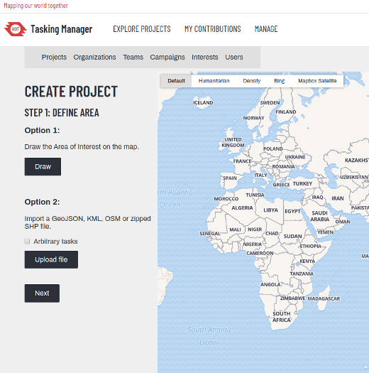
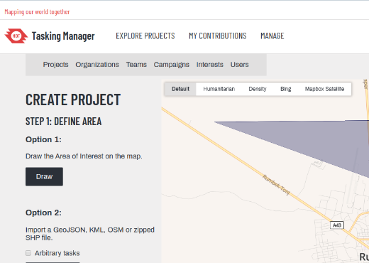
You may choose between defining the area of interest (mapping area) of your mapping project by either:
Define mapping area
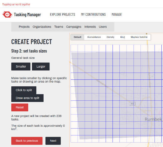
Define tasksAfter the overall mapping area has been defined, it is going be divded into smaller areas called Tasks. This tasks must have a good size so they can be completed rapidly and collaboratively, with many people contributing to a collective project goal.
The mapping area is automatically split into grid cells and each cell becomes a task. Use the
After you’ve adjusted the base grid task size, you can selectively divide certain tasks into four smaller ones with the Task sizes: Please take you time and define very carefully suitable task sizes! The optimal task size depends heavily on the amount of objects that are requested for being mapped in each task. Tasks sizes on rural areas are usually larger than for mapping projects, which are about digitizing buildings in cities por dense settlement areas. Ideally, try mapping an area of the project yourself to see the challenges and effort to map it. This should help you to decide on an optimum square size. It is recommended to choose task sizes that you are confident mappers can complete them in 15-20 minutes.
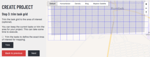
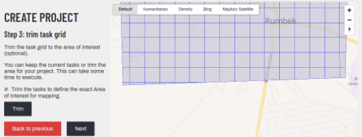
After finalizing the definition of task sizes, click Project Area Trim
After determining the task sizes you will have the option to trim the tasks to the extend of your mapping area. If you simply click on
If you check the box about trimming to the exact area before clicking on
After finalizing a the mapping area trim, click Save the projectGive the project a title (can be edited on the next screen) and click Learn more about how to add descriptions and instructions to the project and get it published to the mappers in our “Edit a mapping project” chapter below. Advanced: Define mapping project areas and tasks with imported geodataGeospatial desktop applications like JOSM or QGIS allow mappers to more precisely draw the areas of interest, compared to the slippy web map inside the Tasking Manager. You can also determine special task shapes and sizes beforehand.
Upload a GeoJSON or KML file of the area of interest to be mapped
After uploading a file to the Tasking Manager you can select if you want to define the tasks either as
Define arbitrary geometries If you uploaded a file to define your project area, that file may also contain the shapes for the individual tasks. E.g. if the area of interest consists of one polygon, the project will have just one task. This should only be used in special cases and for specific reasons. For example, an import of roads project might need custom task shapes or output from a mapping area reduction process. Please note, arbitrary geometries can not be split. They should only be used in special cases, as they have implications on the performance of the tool. Edit a mapping projectAfter a project has been initially set up and created, you have to edit its information and settings:
Description
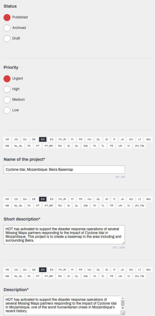
This screen allows you set the project status as Draft, Published, or Archived, priority, a short description used in project listings and the long description available once a mapper has selected the project. Both the short and long description should provide information about why the project exists, who will use the data and the expected the impact the mapping will have. These fields support Markdown text and can include images and videos. Instructions
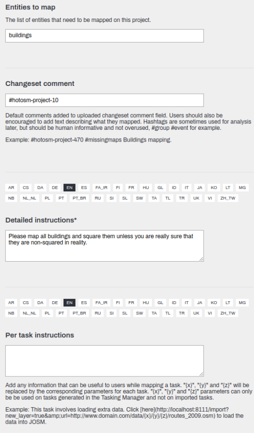
Entities to Map - A list of the features you want users to map. Generally the fewer features the better as they are more likely to get completed.
Changeset Comment - This is the default changeset comment that will be attached to every data upload to OSM. It usually includes something that identifies the Tasking Manager the project resides on and the features that were mapped. It is often used for “hash tags” to help identify the organization requesting and/or doing the mapping. It can also describe the mapping being done, e.g., “Mapping buildings.”
Detailed Instructions - This is where the majority of your detailed instructions will be placed and what we expect every mapper and validator to read carefully and follow. See the below notes on creating good instructions. Per Task Instructions - These will be displayed when a mapper selects a task and also has a special feature that allows Task specific URLs to be crafted based on the typical “slippy map” x, y, z coordinates. Metadata
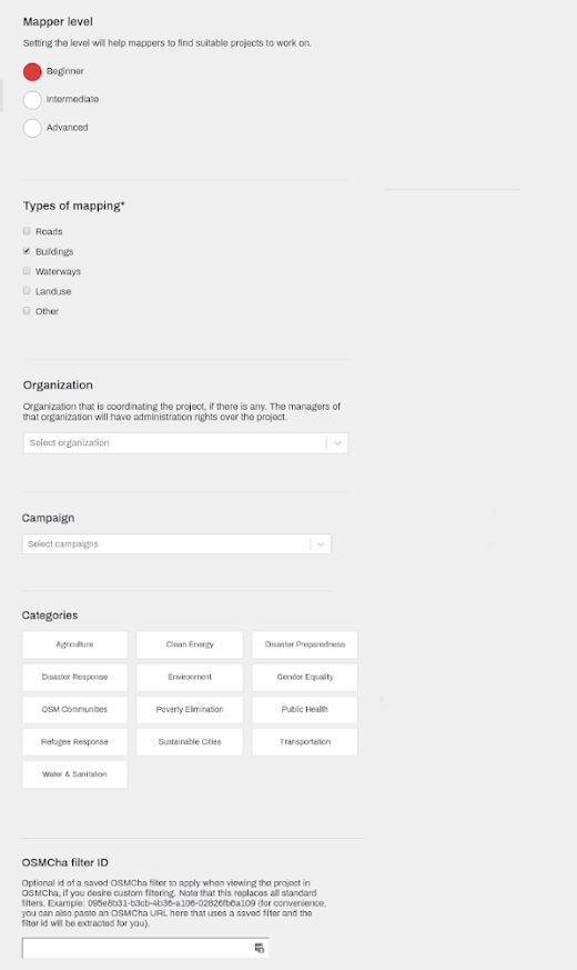
Mapper Level - This is an indication of the difficulty of the mapping project. There are 3 options Beginner, Intermediate and Advanced. This setting is an indication to the mapper what experience level they should have to be most successful in mapping the project. It can be used in project list filtering and the suggested level can be required in the Permissions screen. Type of Mapping - Used in project list filtering and helps mappers find projects they like to map. Organization - The organization whose project managers should have administrative permissions for this project. The organization must have been previously registered with the Tasking Manager. Interests - Used to suggest projects to mappers. Mappers specify their interests in their profile. OSMCha filter ID - OSMCha is offered as a link from the contributions overview. The standard filter confines output to the bounding box of the project and to contributions not older than the project creation date and with the name of the project in the changeset comment. If you think something different would be a better approach to analyze the changesets of your project then either provide an OSMCha URL or an OSMCha filter id here. Priority Areas
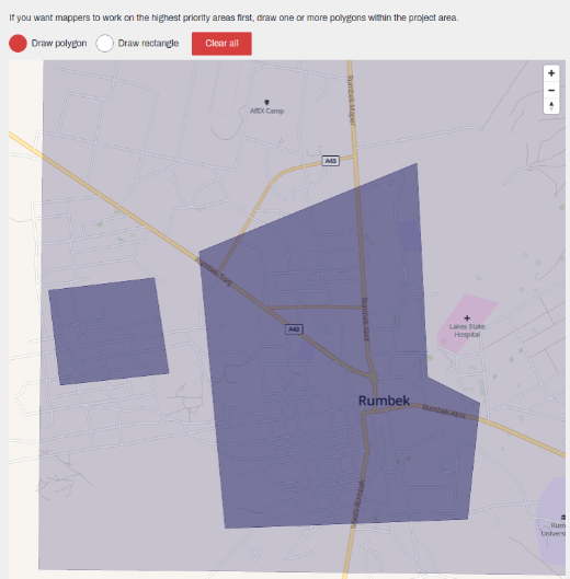
Use the provided tools to draw areas that should be mapped first. You can have multiple priority areas for a Project. You can also change priority areas at any time.
ImageryURL Field - A field that takes a TMS URL that will passed automatically to the OSM Editor the mapper or validator uses. Please follow the example, it is very important it is formatted correctly to work in all editors. License - Optionally, if there is a specific license required for the mapper to accept in using the imagery, you can select it here. If you need a license that is not available, you can contact an administrator for the Tasking Manager installation and ask them to add it. Permissions
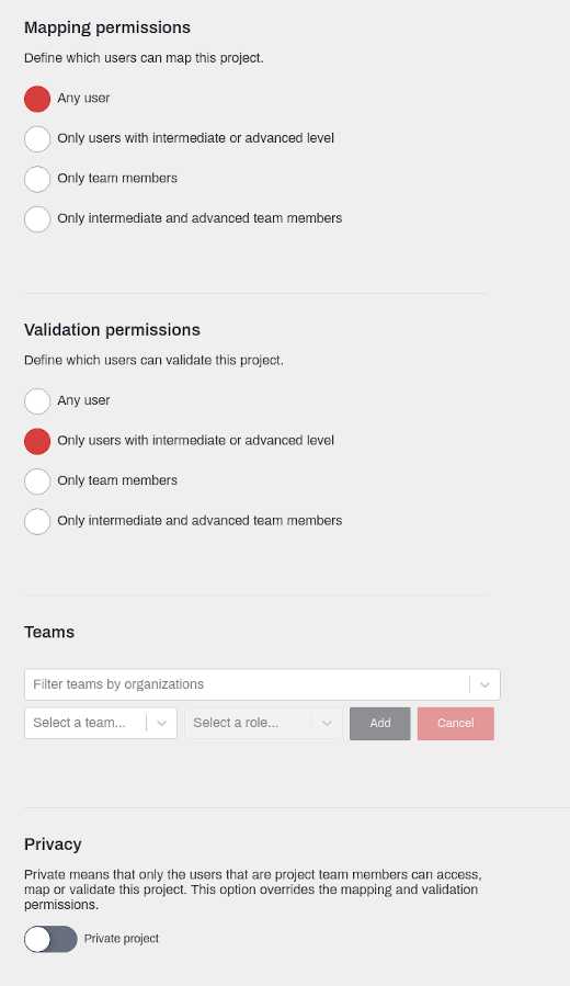
Mapping permissions - Allows you to require that a mapper is at the proper level to map on the project (Metadata screen above). Mapper levels can be set manually, but are automatically applied based on total changesets. You may also require a mapper to be part of a team. Teams can be selected below Validation permissions - Allows you to require that a mapper is at the proper level to validate on the project (Metadata screen above). Mapper levels can be set manually, but are automatically applied based on total changesets. You may also require a validator to be part of a team. Teams can be selected below Teams - Select teams for mapping and validation. If you do so then you can restrict mapping and/or validation to team members using the controls above. You may select several teams for each role. Select a team, select a role and press ‘Add’. Once you added a team you may edit its role or delete the assignment. Privacy - This restricts access to the project to those users who are part of the team to which the project belongs. Settings
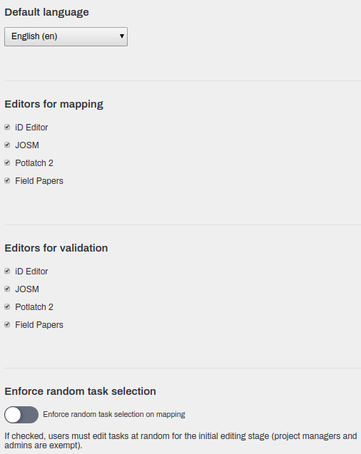
Default Language - Sets the default instructions language for a project. Editors - Restricts the available editors to those checked. You may specify different sets for mapping and for validation. Enforce random selection - If checked then users cannot select a specific task for mapping. Actions
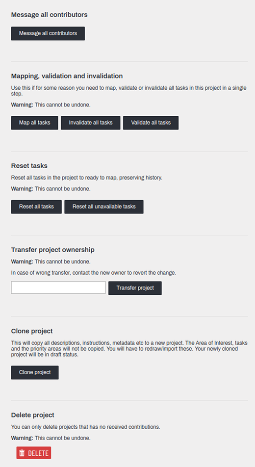
Message all ccontributors - Sends a Tasking Manager message to everyone who has marked a task complete or valid. It can be used to thank contributors and/or guide them to other projects in a portfolio/campaign. It should also be used before using either of the two Validate/Invalidate all Tasks options described below. Mapping, validation and invalidation - This will set the status of all tasks to either mapped, validated or invalidated. Handle with care as there is no undo. Reset tasks - This will reset all tasks to their pristine state but previous actions will still available in the task history. Handle with care as there is no undo. Transfer project ownership - Lets you specify another user who will become the owner of this project. Handle with care as there is no undo. Clone Project - This will create a duplicate of the project except for the mapping area, task grid and priority areas which you will need to re-import or re-draw. Delete Project - This will permanently delete the project from the Tasking Manager. Handle with care as there is no undo. This action is no longer available as soon as any contributions have been made to the project. Instruction NotesPlease use plain language as your target audience may not consist of native English speakers.
Considerations concerning ImageryIn most cases we use the “standard” Bing imagery. But there are situations where you might want to choose an alternative source:
If Bing does not prove adequate then Mapbox is the next choice. You should only look for other sources if neither of these two meet your requirements. In such cases it is not sufficient to choose a license-compatible source and make it available through a WMS or TMS service. Your mapping area has probably already been partially mapped using Bing or Mapbox imagery and there might be a noticeable offset between images. You must have a close look at various locations of your mapping area and determine the offset between your imagery and previously mapped data. If the existing OSM data are offset with respect to your imagery but fit Bing imagery then we usually assume that Bing is the “gold standard” unless we have GPS traces which prove that this assumption is wrong. If there is a constant offset between your imagery and Bing across the mapping area then this might be corrected on the server so that images from various sources loaded in the editor match. If this is not possible, if the offset varies across the mapping area or if existing data are aligned with various sources then it is time for plan B: The important point is that you must develop a strategy for how to cope with these issues and provide detailed instructions to mappers and validators. We strongly suggest that you declare such a project “for experienced mappers only” and explain that experience in this case does not mean having mapped 200+ buildings but having already dealt with alignment issues and different imagery sources. One possible strategy could include these steps:
It is important that step 3 is repeated for every task of the project and the individual task squares should not be too large because imagery offsets can vary considerably across an mapping area, particularly if the terrain is not flat. Even imagery discontinuities may occur across a project - look out for them and advise the contributors of such a problem. Here are some suggested bits of information which you might include in the project instructions:
Proofread and PublishProofread the various tabs to ensure wording and formatting are correct, and instructions are clear. If you need to make changes or refinements to your project, click the ‘Edit’ link in the upper right hand corner of the page. If the project is ready for mapping, click the ‘Publish’ link. Once the project is published, it is available for mapping to anyone with an OSM account, unless a group of users was specified in the ‘Allowed Users’ tab, in which case only the allowed users would be able to work on it. If necessary, edits can still be made to the project after publication by clicking on the ‘Edit’ link.
Was this chapter helpful?
Let us know and help us improve the guides!
|

